
Make a donation
Gear up for your next adventure:
As an Amazon Associate, this site earns from qualifying purchases at no extra cost to you.
Indore topographic map
Click on the map to display elevation.
Make a donation
Gear up for your next adventure:
As an Amazon Associate, this site earns from qualifying purchases at no extra cost to you.
About this map
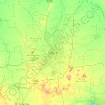
Name: Indore topographic map, elevation, terrain.
Average elevation: 1,821 ft
Minimum elevation: 1,460 ft
Maximum elevation: 2,543 ft
Make a donation
Gear up for your next adventure:
As an Amazon Associate, this site earns from qualifying purchases at no extra cost to you.
Other topographic maps
Click on a map to view its topography, its elevation and its terrain.
Holkar Cricket Stadium
India > Madhya Pradesh > Juni Indore Tahsil > Indore
Average elevation: 1,821 ft
Siddheshwar Hanuman Mandir Udyaan
India > Madhya Pradesh > Juni Indore Tahsil > Indore
Average elevation: 1,804 ft
Make a donation
Gear up for your next adventure:
As an Amazon Associate, this site earns from qualifying purchases at no extra cost to you.