
Make a donation
Gear up for your next adventure:
As an Amazon Associate, this site earns from qualifying purchases at no extra cost to you.
Wettingen topographic map
Click on the map to display elevation.
Make a donation
Gear up for your next adventure:
As an Amazon Associate, this site earns from qualifying purchases at no extra cost to you.
Wettingen
Wettingen has an area, as of 2006, of 10.6 square kilometers (4.1 sq mi). Of this area, 21.6% is used for agricultural purposes, while 39.1% is forested. Of the rest of the land, 37.6% is settled (buildings or roads) and the remainder (1.8%) is non-productive (rivers or lakes). The highest elevation is 859 m (2,818 ft) at the Burghorn, a part of the Lägern, and the lowest elevation is 360 m (1,180 ft) at the Limmat.
Make a donation
Gear up for your next adventure:
As an Amazon Associate, this site earns from qualifying purchases at no extra cost to you.
About this map
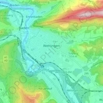
Name: Wettingen topographic map, elevation, terrain.
Location: Wettingen, Bezirk Baden, Aargau, Switzerland (47.44493 8.30851 47.48147 8.37531)
Average elevation: 1,512 ft
Minimum elevation: 1,132 ft
Maximum elevation: 2,579 ft
Make a donation
Gear up for your next adventure:
As an Amazon Associate, this site earns from qualifying purchases at no extra cost to you.