
Thank you for supporting this site ❤️
Make a donation
Make a donation
Gear up for your next adventure:
As an Amazon Associate, this site earns from qualifying purchases at no extra cost to you.
Klaxåsen topographic map
Click on the map to display elevation.
Thank you for supporting this site ❤️
Make a donation
Make a donation
Gear up for your next adventure:
As an Amazon Associate, this site earns from qualifying purchases at no extra cost to you.
About this map
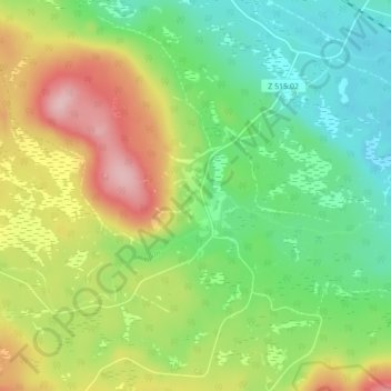
Name: Klaxåsen topographic map, elevation, terrain.
Location: Klaxåsen, Bergs kommun, Jämtland County, Sweden (62.35264 14.42447 62.39264 14.46447)
Average elevation: 1,378 ft
Minimum elevation: 1,135 ft
Maximum elevation: 1,765 ft
Thank you for supporting this site ❤️
Make a donation
Make a donation
Gear up for your next adventure:
As an Amazon Associate, this site earns from qualifying purchases at no extra cost to you.