
Pozuzo topographic map
Click on the map to display elevation.
About this map
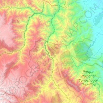
Name: Pozuzo topographic map, elevation, terrain.
Location: Pozuzo, Province of Oxapampa, Pasco, 19251, Peru (-10.52625 -75.98550 -9.95179 -75.45738)
Average elevation: 6,362 ft
Minimum elevation: 830 ft
Maximum elevation: 14,304 ft
Other topographic maps
Click on a map to view its topography, its elevation and its terrain.
Cerro de Pasco
Cerro de Pasco is a city in central Peru, located at the top of the Andean Mountains. It is the capital of both the Pasco Province and the Department of Pasco, and an important mining center of silver, copper, zinc and lead. At an elevation of 4,330 metres (14,210 ft), it is one of the highest cities in the…
Average elevation: 13,907 ft