
Thank you for supporting this site ❤️
Make a donation
Make a donation
Gear up for your next adventure:
As an Amazon Associate, this site earns from qualifying purchases at no extra cost to you.
Lawe Sigala-Gala topographic map
Click on the map to display elevation.
Thank you for supporting this site ❤️
Make a donation
Make a donation
Gear up for your next adventure:
As an Amazon Associate, this site earns from qualifying purchases at no extra cost to you.
About this map
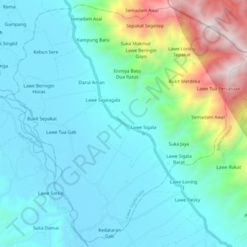
Name: Lawe Sigala-Gala topographic map, elevation, terrain.
Location: Lawe Sigala-Gala, Aceh Tenggara, Aceh, Sumatra, Indonesia (3.29427 97.88102 3.39097 97.98181)
Average elevation: 1,542 ft
Minimum elevation: 308 ft
Maximum elevation: 6,575 ft
Thank you for supporting this site ❤️
Make a donation
Make a donation
Gear up for your next adventure:
As an Amazon Associate, this site earns from qualifying purchases at no extra cost to you.
Other topographic maps
Click on a map to view its topography, its elevation and its terrain.