
Thank you for supporting this site ❤️
Make a donation
Make a donation
Gear up for your next adventure:
As an Amazon Associate, this site earns from qualifying purchases at no extra cost to you.
Ciwaru topographic map
Click on the map to display elevation.
Thank you for supporting this site ❤️
Make a donation
Make a donation
Gear up for your next adventure:
As an Amazon Associate, this site earns from qualifying purchases at no extra cost to you.
About this map
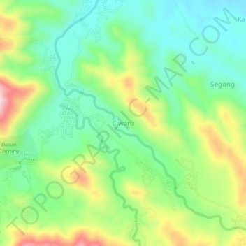
Name: Ciwaru topographic map, elevation, terrain.
Location: Ciwaru, Kuningan, West Java, Java, 45583, Indonesia (-7.09858 108.61660 -7.05858 108.65660)
Average elevation: 709 ft
Minimum elevation: 341 ft
Maximum elevation: 1,375 ft
Thank you for supporting this site ❤️
Make a donation
Make a donation
Gear up for your next adventure:
As an Amazon Associate, this site earns from qualifying purchases at no extra cost to you.
Other topographic maps
Click on a map to view its topography, its elevation and its terrain.
Gunung Ciremai National Park
Indonesia > West Java > Kuningan > Padabeunghar
Average elevation: 2,881 ft