Geolocate

Majenang topographic map

Click on the map to display elevation.

About this map

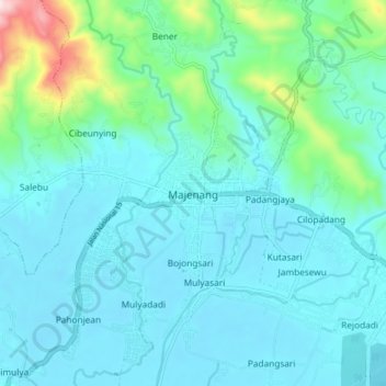
Name: Majenang topographic map, elevation, terrain.

Location: Majenang, Cilacap, Central Java, Java, 53257, Indonesia (-7.33870 108.72259 -7.25870 108.80259)

Average elevation: 272 ft

Minimum elevation: 30 ft

Maximum elevation: 1,640 ft

Other topographic maps

Click on a map to view its topography, its elevation and its terrain.

Desa Rawajaya

Indonesia > Central Java > Cilacap

Average elevation: 13 ft

Sungai Serayu

Indonesia > Central Java > Cilacap > Kedungbenda

Average elevation: 16 ft

Segara Anakan

Indonesia > Central Java > Cilacap > Desa Lomanis > Lomanis

Average elevation: 16 ft

Gear up for your next adventure:

🗃️Trail First Aid Kit - Essential kit for outdoor injuries and emergencies
🪶Thermal Camp Blanket - Extra warmth for cold nights
🏥Hiking First Aid Kits - Comprehensive medical kits for remote trail injuries
🎒Trekking Poles - Sturdy poles for balance and stability on rough terrain
🛰️Satellite Messengers - Emergency SOS and two-way messaging for off-grid adventures

As an Amazon Associate, this site earns from qualifying purchases at no extra cost to you.