
Thank you for supporting this site ❤️
Make a donation
Make a donation
Gear up for your next adventure:
As an Amazon Associate, this site earns from qualifying purchases at no extra cost to you.
Braglia topographic map
Click on the map to display elevation.
Thank you for supporting this site ❤️
Make a donation
Make a donation
Gear up for your next adventure:
As an Amazon Associate, this site earns from qualifying purchases at no extra cost to you.
About this map
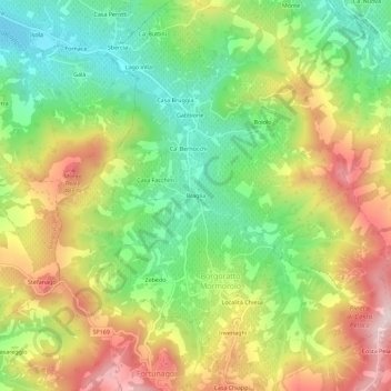
Name: Braglia topographic map, elevation, terrain.
Location: Braglia, Borgoratto Mormorolo, Pavia, Lombardia, Italia (44.91939 9.16972 44.95939 9.20972)
Average elevation: 1,073 ft
Minimum elevation: 518 ft
Maximum elevation: 1,768 ft
Thank you for supporting this site ❤️
Make a donation
Make a donation
Gear up for your next adventure:
As an Amazon Associate, this site earns from qualifying purchases at no extra cost to you.