Geolocate

Armeno topographic map

Click on the map to display elevation.

About this map
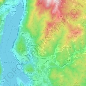
Name: Armeno topographic map, elevation, terrain.

Location: Armeno, Novara, Piedmont, 28011, Italy (45.79709 8.42006 45.87679 8.50695)

Average elevation: 2,047 ft

Minimum elevation: 919 ft

Maximum elevation: 4,596 ft

Other topographic maps

Click on a map to view its topography, its elevation and its terrain.

Case Sparse

Italy > Piedmont > Novara > Galliate

Average elevation: 492 ft

Case Sparse di Cameriano

Italy > Piedmont > Novara > Casalino > Cameriano

Average elevation: 463 ft

Agrate

Italy > Piedmont > Novara

Average elevation: 1,063 ft

Gaggiolo

Italy > Piedmont > Novara

Average elevation: 692 ft

Pisogno

Italy > Piedmont > Novara > Miasino

Average elevation: 1,729 ft

Gear up for your next adventure:

🛡️Insect Repellent - Protection against bugs during outdoor activities
📖Nature Tracking Books - Learn to track wildlife and terrain
🎁Geography Themed Gifts - Unique gift ideas for map lovers and geography enthusiasts
🎒Day Hiking Backpack - Lightweight backpack perfect for day trips and outdoor adventures
🔋Solar Power Banks - Keep your GPS and phone charged in remote wilderness areas

As an Amazon Associate, this site earns from qualifying purchases at no extra cost to you.