
Make a donation
Gear up for your next adventure:
As an Amazon Associate, this site earns from qualifying purchases at no extra cost to you.
Kappel topographic map
Click on the map to display elevation.
Make a donation
Gear up for your next adventure:
As an Amazon Associate, this site earns from qualifying purchases at no extra cost to you.
About this map
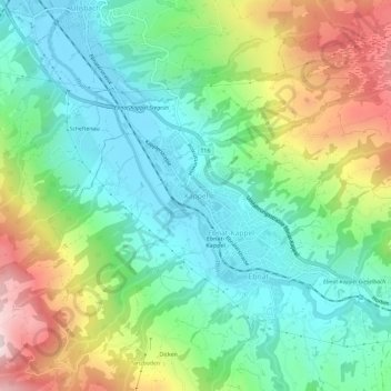
Name: Kappel topographic map, elevation, terrain.
Average elevation: 2,631 ft
Minimum elevation: 2,024 ft
Maximum elevation: 3,865 ft
Make a donation
Gear up for your next adventure:
As an Amazon Associate, this site earns from qualifying purchases at no extra cost to you.
Other topographic maps
Click on a map to view its topography, its elevation and its terrain.
Nesslau
Schweiz > St. Gallen > Wahlkreis Toggenburg > Nesslau
Die Ortschaften Krummenau, Neu St. Johann, Nesslau und Stein liegen im oberen Thurtal und Ennetbühl und Rietbad im Luterental an der Schwägalp-Passstrasse. Zur Gemeinde gehört ein Teil des höchsten Nagelfluh-Bergs Europas, des Speers (1950 m ü. M.), sowie ein Teil des Alpsteins. Das Gemeindegebiet…
Average elevation: 3,609 ft
Ebnat-Kappel
Schweiz > St. Gallen > Wahlkreis Toggenburg
Für die Normalperiode 1991–2020 beträgt die Jahresmitteltemperatur 8,1 °C, wobei im Januar mit −1,1 °C die kältesten und im Juli mit 17,4 °C die wärmsten Monatsmitteltemperaturen gemessen werden. Im Mittel sind hier rund 123 Frosttage und 22 Eistage zu erwarten. Sommertage gibt es im Jahresmittel…
Average elevation: 3,320 ft
Mosnang
Schweiz > St. Gallen > Wahlkreis Toggenburg
Durch Mühlrüti verläuft der 87 Kilometer lange Toggenburger Höhenweg. Er führt in fünf Etappen von Wildhaus über Arvenbüel und Chrüzegg (oberhalb Atzmännig) nach Wil.
Average elevation: 2,677 ft