Make a donation
Gear up for your next adventure:
As an Amazon Associate, this site earns from qualifying purchases at no extra cost to you.
Mawsynram topographic map
Click on the map to display elevation.
Make a donation
Gear up for your next adventure:
As an Amazon Associate, this site earns from qualifying purchases at no extra cost to you.
Mawsynram
Mawsynram is located at 25° 18′ N, 91° 35′ E, at an altitude of about 1,400 meters (4,600 ft), 15 km west of Cherrapunji, in the Khasi Hills in the state of Meghalaya (India).
Make a donation
Gear up for your next adventure:
As an Amazon Associate, this site earns from qualifying purchases at no extra cost to you.
About this map
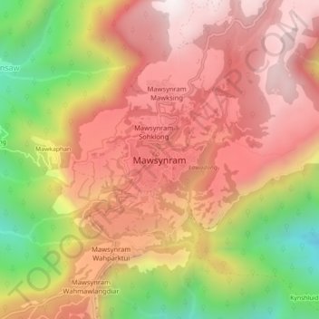
Name: Mawsynram topographic map, elevation, terrain.
Location: Mawsynram, East Khasi Hills, Meghalaya, 793113, India (25.25882 91.54245 25.33882 91.62245)
Average elevation: 3,373 ft
Minimum elevation: 505 ft
Maximum elevation: 5,755 ft
Make a donation
Gear up for your next adventure:
As an Amazon Associate, this site earns from qualifying purchases at no extra cost to you.
