
Thank you for supporting this site ❤️
Make a donation
Make a donation
Gear up for your next adventure:
As an Amazon Associate, this site earns from qualifying purchases at no extra cost to you.
Konso topographic map
Click on the map to display elevation.
Thank you for supporting this site ❤️
Make a donation
Make a donation
Gear up for your next adventure:
As an Amazon Associate, this site earns from qualifying purchases at no extra cost to you.
About this map
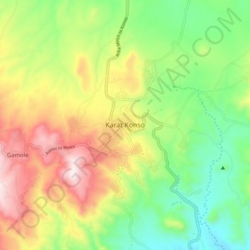
Name: Konso topographic map, elevation, terrain.
Location: Konso, Segen Peoples', South Ethiopia Regional State, Ethiopia (5.29982 37.40237 5.37982 37.48237)
Average elevation: 4,491 ft
Minimum elevation: 3,625 ft
Maximum elevation: 5,699 ft
Thank you for supporting this site ❤️
Make a donation
Make a donation
Gear up for your next adventure:
As an Amazon Associate, this site earns from qualifying purchases at no extra cost to you.