
Make a donation
Gear up for your next adventure:
As an Amazon Associate, this site earns from qualifying purchases at no extra cost to you.
Playa Blanca topographic map
Click on the map to display elevation.
Make a donation
Gear up for your next adventure:
As an Amazon Associate, this site earns from qualifying purchases at no extra cost to you.
About this map
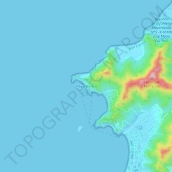
Name: Playa Blanca topographic map, elevation, terrain.
Average elevation: 72 ft
Minimum elevation: -3 ft
Maximum elevation: 869 ft
Make a donation
Gear up for your next adventure:
As an Amazon Associate, this site earns from qualifying purchases at no extra cost to you.
Other topographic maps
Click on a map to view its topography, its elevation and its terrain.
Parque de los Novios
Colombia > Magdalena > Santa Marta > Perímetro Urbano Santa Marta
Average elevation: 26 ft
El Rodadero
Colombia > Magdalena > Santa Marta > Perímetro Urbano Santa Marta
Average elevation: 98 ft
Playa Salguero
Colombia > Magdalena > Santa Marta > Perímetro Urbano Santa Marta
Average elevation: 39 ft