
Daulat Beg Oldi topographic map
Interactive map
Click on the map to display elevation.
About this map
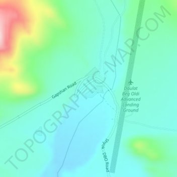
Name: Daulat Beg Oldi topographic map, elevation, terrain.
Location: Daulat Beg Oldi, Nubra, Leh district, Ladakh, India (35.38144 77.91114 35.40144 77.93114)
Average elevation: 16,683 ft
Minimum elevation: 16,486 ft
Maximum elevation: 17,398 ft
The Indian government first announced plans in 2001 to construct a motorable road from Leh to its destination at Daulat Beg Oldi. The road was completed in 2019. The 255-km is Darbuk-Shyok-DBO Road runs at elevations between 4,000–5,000 metres (13,000–16,000 ft). The travel time is said to be six hours.
Other topographic maps
Click on a map to view its topography, its elevation and its terrain.
Karakoram Pass
Karakoram Pass, Nubra, Leh District, Ladakh, India
Average elevation: 18,114 ft
Siachen Glacier
Siachen Glacier, Nubra, Leh district, Ladakh, India
Average elevation: 17,874 ft