Geolocate

High Easter topographic map

Click on the map to display elevation.

About this map

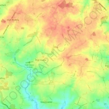
Name: High Easter topographic map, elevation, terrain.

Location: High Easter, Uttlesford, Essex, England, United Kingdom (51.77993 0.32315 51.84128 0.41464)

Average elevation: 249 ft

Minimum elevation: 161 ft

Maximum elevation: 312 ft

Gear up for your next adventure:

👟Men's Trail Runners - Lightweight footwear for fast-paced exploration and light hiking
🧭GPS Watch Accessories - Bands and chargers for GPS watches
🚁Photography Drones - Capture stunning aerial views of landforms and topography
🔭Compact Binoculars - HD vision for scouting terrain and identifying distant landmarks
🪄Magnetic Compass - Accurate compass for navigation

As an Amazon Associate, this site earns from qualifying purchases at no extra cost to you.