
Thank you for supporting this site ❤️
Make a donation
Make a donation
Gear up for your next adventure:
As an Amazon Associate, this site earns from qualifying purchases at no extra cost to you.
Reichenspitze topographic map
Click on the map to display elevation.
Thank you for supporting this site ❤️
Make a donation
Make a donation
Gear up for your next adventure:
As an Amazon Associate, this site earns from qualifying purchases at no extra cost to you.
Reichenspitze
La Reichenspitze est une montagne qui s’élève à 3 303 m d’altitude dans les Alpes de Zillertal, en Autriche.
Thank you for supporting this site ❤️
Make a donation
Make a donation
Gear up for your next adventure:
As an Amazon Associate, this site earns from qualifying purchases at no extra cost to you.
About this map
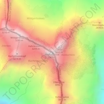
Name: Reichenspitze topographic map, elevation, terrain.
Location: Reichenspitze, Brandberg, Bezirk Schwaz, Tyrol, Autriche (47.13960 12.11062 47.13970 12.11072)
Average elevation: 9,088 ft
Minimum elevation: 7,136 ft
Maximum elevation: 10,653 ft
Thank you for supporting this site ❤️
Make a donation
Make a donation
Gear up for your next adventure:
As an Amazon Associate, this site earns from qualifying purchases at no extra cost to you.