Geolocate

Mazamari topographic map

Click on the map to display elevation.

About this map

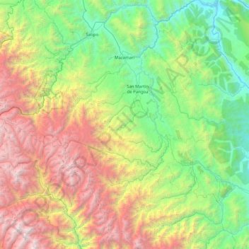
Name: Mazamari topographic map, elevation, terrain.

Location: Mazamari, Province of Satipo, Junín, Peru (-11.93383 -74.61210 -11.14764 -73.92444)

Average elevation: 6,283 ft

Minimum elevation: 974 ft

Maximum elevation: 17,283 ft

Other topographic maps

Click on a map to view its topography, its elevation and its terrain.

Potsoteni

Peru > Junín > Mazamari

Average elevation: 1,414 ft

Cañete

Peru > Junín > Mazamari

Average elevation: 2,418 ft

Cañete

Peru > Junín > Mazamari > Cañete

Average elevation: 2,362 ft

Gear up for your next adventure:

🎒Hydration Pack - Hands‑free water reservoir for long hikes
🧢Sun Protection Hats - Wide-brimmed and UPF-rated hats for high-altitude sun safety
🥄Camping Utensil Set - Lightweight utensils for outdoor meals
🔦Powerful Headlamps - Ultra-bright hands-free lighting for night navigation
📱Solar Portable Charger - Solar power bank for charging devices off‑grid

As an Amazon Associate, this site earns from qualifying purchases at no extra cost to you.