Geolocate

Llanduma topographic map

Click on the map to display elevation.

About this map

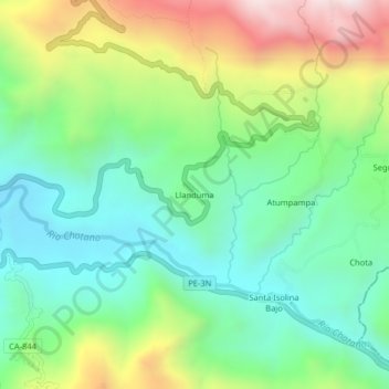
Name: Llanduma topographic map, elevation, terrain.

Location: Llanduma, Cochabamba, Chota, Cajamarca, Perú (-6.49407 -78.88073 -6.45407 -78.84073)

Average elevation: 6,486 ft

Minimum elevation: 5,466 ft

Maximum elevation: 8,474 ft

Other topographic maps

Click on a map to view its topography, its elevation and its terrain.

Provincia de Chota

Perú > Cajamarca > Cochabamba

Average elevation: 7,598 ft

Gear up for your next adventure:

🧢Outdoor Hiking Hat - Sun protection hat for outdoor explorers
📱Solar Portable Charger - Solar power bank for charging devices off‑grid
🌡️Handheld Weather Meters - Measure wind, temp, and pressure for safe mountain travel
😴Insulated Sleeping Pads - Compact and warm pads for high-elevation camping
🛶Inflatable Kayak - Portable kayak for rivers, lakes, and expeditions

As an Amazon Associate, this site earns from qualifying purchases at no extra cost to you.