Geolocate

Lowell topographic map

Click on the map to display elevation.

About this map

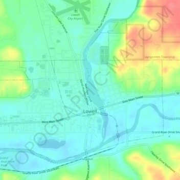
Name: Lowell topographic map, elevation, terrain.

Location: Lowell, Kent County, Michigan, United States (42.92351 -85.37144 42.95233 -85.32147)

Average elevation: 676 ft

Minimum elevation: 610 ft

Maximum elevation: 833 ft

Kent County trails, hiking, mountain biking, running and outdoor activities

Other topographic maps

Click on a map to view its topography, its elevation and its terrain.

Crescent Park

United States > Michigan > Kent County > Grand Rapids

Average elevation: 669 ft

Harvard Lake

United States > Michigan > Kent County > Harvard

Average elevation: 876 ft

Lookout Park

United States > Michigan > Kent County > Grand Rapids

Average elevation: 669 ft

Grattan

United States > Michigan > Kent County

Average elevation: 856 ft

Cobb Lake

United States > Michigan > Kent County > Bowne Township

Average elevation: 827 ft

Parnell

United States > Michigan > Kent County > Grattan Township

Average elevation: 850 ft

Grattan

United States > Michigan > Kent County

Average elevation: 856 ft

Kettle Lake

United States > Michigan > Kent County

Average elevation: 784 ft

Richmond Park

United States > Michigan > Kent County > Grand Rapids

Average elevation: 663 ft

Creekside Park

United States > Michigan > Kent County > Lowell

Average elevation: 659 ft

Gear up for your next adventure:

🔭Compact Binoculars - HD vision for scouting terrain and identifying distant landmarks
🧤Hiking Gloves - Protective gloves for rugged trails
👟Trail Running Shoes - Lightweight shoes for trail runners
📱Solar Portable Charger - Solar power bank for charging devices off‑grid
🎒Day Hiking Backpack - Lightweight backpack perfect for day trips and outdoor adventures

As an Amazon Associate, this site earns from qualifying purchases at no extra cost to you.