Geolocate

Grattan topographic map

Click on the map to display elevation.

About this map
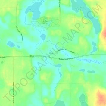
Name: Grattan topographic map, elevation, terrain.

Location: Grattan, Grattan Township, Kent County, Michigan, United States (43.06420 -85.40113 43.10420 -85.36113)

Average elevation: 856 ft

Minimum elevation: 801 ft

Maximum elevation: 955 ft

Kent County trails, hiking, mountain biking, running and outdoor activities

Other topographic maps

Click on a map to view its topography, its elevation and its terrain.
Grand Rapids

United States > Michigan > Kent County

Grand Rapids is situated in a region characterized by relatively flat terrain that gently undulates, influenced by the glacial activity that shaped much of the Midwest. The city itself sits at an elevation of approximately 640 feet (195 meters) above sea level, with the surrounding landscape showcasing low…

Average elevation: 709 ft

Grand Rapids

United States > Michigan > Kent County

Grand Rapids developed on the banks of the Grand River, where there was once a set of rapids, at an altitude of 610 feet (186 m) above sea level. Ships could navigate on the river up to this fall line, stopping because of the rapids. The river valley is flat and narrow, surrounded by steep hills and bluffs.…

Average elevation: 709 ft

Cedar Springs

United States > Michigan > Kent County

Average elevation: 860 ft

Walker

United States > Michigan > Kent County

Average elevation: 686 ft

Vergennes Township

United States > Michigan > Kent County

Average elevation: 794 ft

Sparta

United States > Michigan > Kent County

Average elevation: 771 ft

Oakfield Township

United States > Michigan > Kent County

Average elevation: 869 ft

Harvard Lake

United States > Michigan > Kent County > Harvard

Average elevation: 876 ft

Kentwood

United States > Michigan > Kent County

Average elevation: 709 ft

Caledonia

United States > Michigan > Kent County

Average elevation: 797 ft

Byron Township

United States > Michigan > Kent County

Average elevation: 725 ft

Tyrone Township

United States > Michigan > Kent County

Average elevation: 817 ft

East Grand Rapids

United States > Michigan > Kent County

Average elevation: 761 ft

Solon Township

United States > Michigan > Kent County

Average elevation: 863 ft

Rockford

United States > Michigan > Kent County

Average elevation: 784 ft

Wyoming

United States > Michigan > Kent County

Average elevation: 669 ft

Courtland Township

United States > Michigan > Kent County

Average elevation: 883 ft

Sand Lake

United States > Michigan > Kent County

Average elevation: 909 ft

Lookout Park

United States > Michigan > Kent County > Grand Rapids

Average elevation: 669 ft

Grandville

United States > Michigan > Kent County

Average elevation: 633 ft

Lowell

United States > Michigan > Kent County

Average elevation: 676 ft

Crescent Park

United States > Michigan > Kent County > Grand Rapids

Average elevation: 669 ft

Kettle Lake

United States > Michigan > Kent County

Average elevation: 784 ft

Spencer Township

United States > Michigan > Kent County

Average elevation: 876 ft

Lowell

United States > Michigan > Kent County

Average elevation: 676 ft

Lowell

United States > Michigan > Kent County

Average elevation: 676 ft

Nelson Township

United States > Michigan > Kent County

Average elevation: 902 ft

Walker

United States > Michigan > Kent County

Average elevation: 686 ft

Cobb Lake

United States > Michigan > Kent County > Bowne Township

Average elevation: 827 ft

Grand Rapids

United States > Michigan > Kent County

Grand Rapids developed on the banks of the Grand River, where there was once a set of rapids, at an altitude of 610 feet (186 m) above sea level. Ships could navigate on the river up to this fall line, stopping because of the rapids. The river valley is flat and narrow, surrounded by steep hills and bluffs.…

Average elevation: 709 ft

Kent City

United States > Michigan > Kent County

Average elevation: 823 ft

Algoma Township

United States > Michigan > Kent County

Average elevation: 794 ft

Rockford

United States > Michigan > Kent County

Average elevation: 784 ft

Byron Township

United States > Michigan > Kent County

Average elevation: 725 ft

Kentwood

United States > Michigan > Kent County

Average elevation: 709 ft

East Grand Rapids

United States > Michigan > Kent County

Average elevation: 761 ft

Vergennes Township

United States > Michigan > Kent County

Average elevation: 794 ft

Richmond Park

United States > Michigan > Kent County > Grand Rapids

Average elevation: 663 ft

Gear up for your next adventure:

🖼️Topo Map Wall Art - Decorative topographic prints of famous peaks and regions
🔭Telescopic Hiking Pole - Adjustable pole for hiking stability
🧢Sun Protection Hats - Wide-brimmed and UPF-rated hats for high-altitude sun safety
🪄Magnetic Compass - Accurate compass for navigation
🦺Reflective Outdoor Gear - Safety gear for low‑light conditions

As an Amazon Associate, this site earns from qualifying purchases at no extra cost to you.