Geolocate

Gordon Heights topographic map

Click on the map to display elevation.

About this map

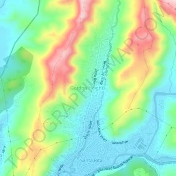
Name: Gordon Heights topographic map, elevation, terrain.

Location: Gordon Heights, Zambales, Central Luzon, 2200, Philippines (14.84554 120.27032 14.88554 120.31032)

Average elevation: 394 ft

Minimum elevation: 26 ft

Maximum elevation: 1,125 ft

Gear up for your next adventure:

👖Convertible Hiking Pants - Versatile zip-off pants for changing altitudes and temperatures
🥩Freeze-Dried Meals - Nutritious and lightweight food for remote expeditions
🏕️Family Camping Gear - Essentials for group camping trips
🔦LED Headlamp - Bright and durable LED headlamp for night navigation
🧯Emergency Survival Kit - All‑in‑one survival essentials for the backcountry

As an Amazon Associate, this site earns from qualifying purchases at no extra cost to you.