
Make a donation
Gear up for your next adventure:
As an Amazon Associate, this site earns from qualifying purchases at no extra cost to you.
Riksingen topographic map
Click on the map to display elevation.
Make a donation
Gear up for your next adventure:
As an Amazon Associate, this site earns from qualifying purchases at no extra cost to you.
Riksingen
Riksingen bevindt zich op de grens van vochtig- en droog-Haspengouw. De hoogte varieert tussen 80 en 120 meter. Ten westen van Riksingen ligt het brongebied van de Lerebeek, welke via de Mombeek en de Herk uiteindelijk in de Demer uitmondt. Het belangrijkste natuurgebied is het Hasselbos, dat zich ten noorden van het dorp bevindt.
Make a donation
Gear up for your next adventure:
As an Amazon Associate, this site earns from qualifying purchases at no extra cost to you.
About this map
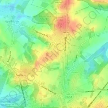
Name: Riksingen topographic map, elevation, terrain.
Location: Riksingen, Tongeren, Limburg, België (50.79361 5.44694 50.81434 5.47237)
Average elevation: 305 ft
Minimum elevation: 223 ft
Maximum elevation: 394 ft
Make a donation
Gear up for your next adventure:
As an Amazon Associate, this site earns from qualifying purchases at no extra cost to you.