Geolocate

Challock topographic map

Click on the map to display elevation.

About this map

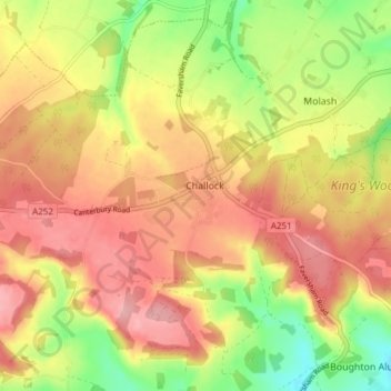
Name: Challock topographic map, elevation, terrain.

Location: Challock, Ashford, Kent, England, United Kingdom (51.19723 0.83231 51.24009 0.90791)

Average elevation: 446 ft

Minimum elevation: 210 ft

Maximum elevation: 627 ft

Other topographic maps

Click on a map to view its topography, its elevation and its terrain.

Hamstreet

United Kingdom > England > Kent > Ashford

Average elevation: 72 ft

Hinxhill

United Kingdom > England > Kent > Ashford

Average elevation: 167 ft

Gear up for your next adventure:

🛡️Insect Repellent - Protection against bugs during outdoor activities
Camping Coffee Makers - Enjoy premium coffee at the summit or campsite
🦶Carbon Trekking Poles - Reduce knee impact on steep descents with ultra-light poles
🔭Compact Binoculars - HD vision for scouting terrain and identifying distant landmarks
🪶Wildlife Field Guides - Learn animal tracking and species ID

As an Amazon Associate, this site earns from qualifying purchases at no extra cost to you.