Geolocate

Punta Negra topographic map

Click on the map to display elevation.

About this map

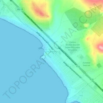
Name: Punta Negra topographic map, elevation, terrain.

Location: Punta Negra, Lima, Lima Metropolitana, Lima, 15851, Perú (-12.38556 -76.81519 -12.34556 -76.77519)

Average elevation: 102 ft

Minimum elevation: -3 ft

Maximum elevation: 545 ft

Other topographic maps

Click on a map to view its topography, its elevation and its terrain.

Santa Rosa

Perú > Lima > Punta Negra

Average elevation: 52 ft

Santa Rosa

Perú > Lima > Punta Negra

Average elevation: 52 ft

Gear up for your next adventure:

🔌Solar Panel Charger - Charge gear sustainably outdoors
🥄Camping Utensil Set - Lightweight utensils for outdoor meals
👟Men's Trail Runners - Lightweight footwear for fast-paced exploration and light hiking
🪶Paracord Bracelet - Survival bracelet with built‑in tools
🗺️NatGeo Topo Maps - High-quality waterproof printed topographic maps of US Parks

As an Amazon Associate, this site earns from qualifying purchases at no extra cost to you.