Geolocate

Tambobamba topographic map

Click on the map to display elevation.

About this map

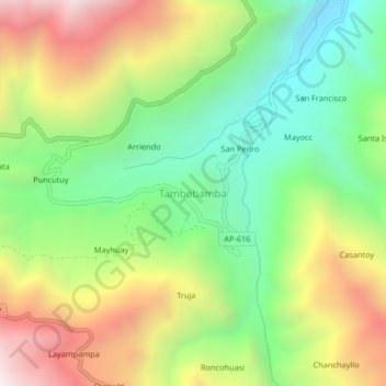
Name: Tambobamba topographic map, elevation, terrain.

Location: Tambobamba, Huanipaca, Abancay, Apurímac, Perú (-13.50230 -72.90908 -13.46230 -72.86908)

Average elevation: 9,104 ft

Minimum elevation: 7,182 ft

Maximum elevation: 11,768 ft

Other topographic maps

Click on a map to view its topography, its elevation and its terrain.

Huanipaca

Perú > Apurímac > Huanipaca

Average elevation: 10,308 ft

Gear up for your next adventure:

🧭Map Reading Tools - Tools and kits for map navigation
🧭Compass with Lanyard - Easy‑carry compass for navigation
🏫Relief Map Kits - Hands-on tools for teaching landforms and elevation
🔥Plasma Lighters - Windproof lighters that work in any weather condition
🪶Camping Sleeping Pad - Comfortable sleeping pad for backpacking

As an Amazon Associate, this site earns from qualifying purchases at no extra cost to you.