
Hagen topographic map
Click on the map to display elevation.
Hagen
42 per cent of Hagen's municipal area consists of forest. The four rivers in Hagen stretch over a length of 52.2 km: Ruhr 11.5 km, Lenne 13.1 km, Volme 21.3 km and Ennepe 6.3 km. The difference in altitude from the lowest point on the Ruhr near Vorhalle (86 metres above sea level) to the highest point east of Bölling ♁51° 18′ N, 7° 34′ E (438 metres above sea level) is 352 metres.
About this map
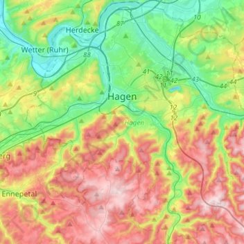
Name: Hagen topographic map, elevation, terrain.
Location: Hagen, North Rhine-Westphalia, Germany (51.26488 7.37591 51.41857 7.59890)
Average elevation: 755 ft
Minimum elevation: 256 ft
Maximum elevation: 1,447 ft
Other topographic maps
Click on a map to view its topography, its elevation and its terrain.
Bochum
Germany > North Rhine-Westphalia > Bochum
The city lies on the low rolling hills of Bochum land ridge (Bochumer Landrücken), part of the Ruhrhöhen (highest elevations) between the Ruhr and Emscher rivers at the border of the southern and northern Ruhr coal region. The highest point of the city is at Kemnader Straße (Kemnader Street) in Stiepel at…
Average elevation: 351 ft
Bend
Germany > North Rhine-Westphalia > Städteregion Aachen > Stolberg > Schevenhütte
Average elevation: 876 ft