
Chilime Khola topographic map
Interactive map
Click on the map to display elevation.
About this map
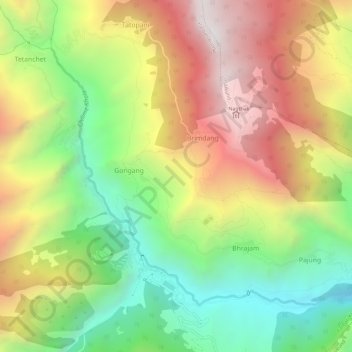
Name: Chilime Khola topographic map, elevation, terrain.
Average elevation: 7,835 ft
Minimum elevation: 5,128 ft
Maximum elevation: 10,961 ft
Other topographic maps
Click on a map to view its topography, its elevation and its terrain.
Dhulikhel
Nepal > Central Development Region > Dhulikhel
Dhulikhel, Kavrepalanchok, Bagmati, Central Development Region, Nepal
Average elevation: 4,711 ft
Gokarneshwar
Nepal > Central Development Region > Gokarneshwar
Gokarneshwar, Kathmandu, Bagmati, Central Development Region, 89977, Nepal
Average elevation: 4,573 ft
Chillime
Nepal > Central Development Region > Chillime
Chillime, Rasuwa, Bagmati, Central Development Region, Nepal
Average elevation: 7,198 ft
Shankarpur
Nepal > Central Development Region > Shankarpur
Shankarpur, Sarlahi, Janakpur, Central Development Region, Nepal
Average elevation: 354 ft
Central Development Region
Nepal > Central Development Region
Central Development Region, Nepal
Average elevation: 5,072 ft
Shikarpur
Nepal > Central Development Region > Shikarpur
Shikarpur, Makwanpur, Narayani, Central Development Region, Nepal
Average elevation: 2,083 ft