
Make a donation
Gear up for your next adventure:
As an Amazon Associate, this site earns from qualifying purchases at no extra cost to you.
Bear Mountain State Park topographic map
Click on the map to display elevation.
Make a donation
Gear up for your next adventure:
As an Amazon Associate, this site earns from qualifying purchases at no extra cost to you.
Bear Mountain State Park
There are over 50 official trails covering 235 miles (378 km), featuring a wide range of difficulties and elevation changes.
Make a donation
Gear up for your next adventure:
As an Amazon Associate, this site earns from qualifying purchases at no extra cost to you.
About this map
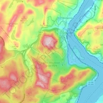
Name: Bear Mountain State Park topographic map, elevation, terrain.
Average elevation: 545 ft
Minimum elevation: 0 ft
Maximum elevation: 1,293 ft
Rockland County trails, hiking, mountain biking, running and outdoor activities
Make a donation
Gear up for your next adventure:
As an Amazon Associate, this site earns from qualifying purchases at no extra cost to you.
Other topographic maps
Click on a map to view its topography, its elevation and its terrain.
Tomkins Cove
United States > New York > Rockland County > Town of Stony Point
Average elevation: 223 ft
Fort Clinton
United States > New York > Rockland County > Town of Stony Point
Average elevation: 364 ft