Geolocate

Kanne topographic map

Click on the map to display elevation.

Kanne

De geschiedenis van Kanne gaat terug tot de Romeinen die de plaatselijke mergelsteen reeds ontgonnen. Ook een Romeinse begraafplaats werd er gevonden. Voor die tijd lag er al een hoogteversterking op Caestert.

About this map

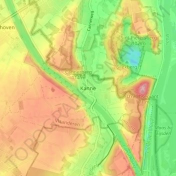
Name: Kanne topographic map, elevation, terrain.

Location: Kanne, Riemst, Tongeren, Limburg, Vlaanderen, 4690 EBEN-EMAEL, België (50.79416 5.64922 50.83416 5.68922)

Average elevation: 272 ft

Minimum elevation: 33 ft

Maximum elevation: 502 ft

Gear up for your next adventure:

🧴Hand Sanitizer - Keep hands clean while hiking
📶Satellite Messenger - Communication device off‑grid
🌄Hiking Binoculars - Compact binoculars for scenic views and trail spotting
🥾Men's Hiking Boots - Durable, waterproof footwear for rugged terrain and steep inclines
🪶Survival Guide Book - Expert advice for emergency preparedness

As an Amazon Associate, this site earns from qualifying purchases at no extra cost to you.