Geolocate

Taranto topographic map

Click on the map to display elevation.

About this map

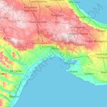
Name: Taranto topographic map, elevation, terrain.

Location: Taranto, Apulia, Italy (40.29447 16.69731 40.80325 17.80042)

Average elevation: 502 ft

Minimum elevation: -7 ft

Maximum elevation: 1,713 ft

Other topographic maps

Click on a map to view its topography, its elevation and its terrain.

Altamura

Italy > Apulia > Bari > Altamura

Average elevation: 1,342 ft

Battaglia di Canne

Italy > Apulia > Barletta

Average elevation: 72 ft

Pozzo Faceto

Italy > Apulia > Brindisi > Fasano

Average elevation: 207 ft

San Domino

Italy > Apulia > Foggia > San Nicola

Average elevation: 16 ft

Marinara

Italy > Apulia > Taranto > Mottola

Average elevation: 856 ft

Ofanto

Italy > Apulia > Canosa di Puglia

Average elevation: 180 ft

Saturo

Italy > Apulia > Taranto > Leporano

Average elevation: 39 ft

Polignano a Mare

Italy > Apulia > Bari

Average elevation: 138 ft

Padre Pio

Italy > Apulia > Foggia > Cerignola

Average elevation: 371 ft

Santa Maria al Bagno

Italy > Apulia > Lecce > Nardò

Average elevation: 105 ft

Torre Canne

Italy > Apulia > Brindisi > Fasano

Average elevation: 26 ft

Torre Chianca

Italy > Apulia > Lecce > Lecce

Average elevation: 7 ft

Monte Belvedere

Italy > Apulia > Bari > Altamura

Average elevation: 1,496 ft

Gear up for your next adventure:

🚗GPS Dash Cams - Record your scenic drives through mountain passes and canyons
🪄Magnetic Compass - Accurate compass for navigation
📦Gear Storage Bags - Organize and protect outdoor equipment
Camping Coffee Makers - Enjoy premium coffee at the summit or campsite
🧺Microfiber Travel Towels - Compact and fast-drying towels for trail use

As an Amazon Associate, this site earns from qualifying purchases at no extra cost to you.