Geolocate

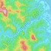
Caimanera topographic map

Click on the map to display elevation.

About this map

Name: Caimanera topographic map, elevation, terrain.

Location: Caimanera, Guantánamo, 09593, Cuba (19.88106 -75.35659 20.06482 -74.95171)

Average elevation: 151 ft

Minimum elevation: -10 ft

Maximum elevation: 1,913 ft

Other topographic maps

Click on a map to view its topography, its elevation and its terrain.

Guantanamo

Cuba > Guantánamo > Guantanamo

Average elevation: 482 ft

Toa

Cuba > Guantánamo > Baracoa

Average elevation: 545 ft

Los Jagüeyes

Cuba > Guantánamo > Maisí

Average elevation: 1,211 ft

Los Jagüeyes

Cuba > Guantánamo > Maisí

Average elevation: 1,211 ft

Vega Larga

Cuba > Guantánamo > Baracoa

Average elevation: 180 ft

Gear up for your next adventure:

🪶Trail Camera - Capture wildlife on your hikes
🦶Carbon Trekking Poles - Reduce knee impact on steep descents with ultra-light poles
🪓Survival Multi‑Tool - Versatile tool for camp and trail tasks
🧯Emergency Survival Kit - All‑in‑one survival essentials for the backcountry
🩹Survival Bandages - High‑quality bandages for emergencies

As an Amazon Associate, this site earns from qualifying purchases at no extra cost to you.