
Make a donation
Gear up for your next adventure:
As an Amazon Associate, this site earns from qualifying purchases at no extra cost to you.
Groß Leuthen topographic map
Click on the map to display elevation.
Make a donation
Gear up for your next adventure:
As an Amazon Associate, this site earns from qualifying purchases at no extra cost to you.
Groß Leuthen
Am ersten Februarwochenende findet das Zampern statt und am darauf folgenden Wochenende der Eierkuchenball. Seit dem Sommer 2006 gibt es im Ort den Scheunensommer, der von Mai bis Oktober für jeden kulturellen Geschmack etwas zu bieten hat. An einem Juliwochenende wird am Dorfstrand das traditionelle „Strandfest“ durch den Dorfclub organisiert. Der Höhepunkt des Strandfestes ist am Abend der Bootskorso mit einem Programm und anschließendem Höhenfeuerwerk. Jeweils Anfang November ist im hiesigen Gasthaus die Kirmes.
Make a donation
Gear up for your next adventure:
As an Amazon Associate, this site earns from qualifying purchases at no extra cost to you.
About this map
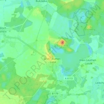
Name: Groß Leuthen topographic map, elevation, terrain.
Average elevation: 167 ft
Minimum elevation: 128 ft
Maximum elevation: 253 ft
Make a donation
Gear up for your next adventure:
As an Amazon Associate, this site earns from qualifying purchases at no extra cost to you.
Other topographic maps
Click on a map to view its topography, its elevation and its terrain.