Geolocate

Mossyrock topographic map

Click on the map to display elevation.

About this map

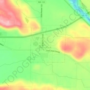
Name: Mossyrock topographic map, elevation, terrain.

Location: Mossyrock, Lewis County, Washington, United States (46.52537 -122.49166 46.53567 -122.47544)

Average elevation: 699 ft

Minimum elevation: 436 ft

Maximum elevation: 994 ft

Lewis County trails, hiking, mountain biking, running and outdoor activities

Other topographic maps

Click on a map to view its topography, its elevation and its terrain.

Pompey Peak

United States > Washington > Lewis County

Average elevation: 3,793 ft

Narada Falls

United States > Washington > Lewis County

Average elevation: 4,738 ft

Bremer

United States > Washington > Lewis County

Average elevation: 1,411 ft

Packwood

United States > Washington > Lewis County

Average elevation: 1,243 ft

Walupt Creek Falls

United States > Washington > Lewis County

Average elevation: 3,799 ft

Mineral

United States > Washington > Lewis County > Mineral

Average elevation: 1,578 ft

Onalaska

United States > Washington > Lewis County

Average elevation: 558 ft

Adna

United States > Washington > Lewis County

Average elevation: 269 ft

Vader

United States > Washington > Lewis County

Average elevation: 243 ft

Glenoma

United States > Washington > Lewis County

Average elevation: 1,161 ft

Chimney Rock

United States > Washington > Lewis County

Average elevation: 5,226 ft

Gear up for your next adventure:

🦶Carbon Trekking Poles - Reduce knee impact on steep descents with ultra-light poles
🔭Compact Binoculars - HD vision for scouting terrain and identifying distant landmarks
🏥Hiking First Aid Kits - Comprehensive medical kits for remote trail injuries
🔋Rechargeable Batteries - Power up your outdoor devices
📱Heavy-Duty Phone Cases - Drop-proof and waterproof protection for outdoor navigation

As an Amazon Associate, this site earns from qualifying purchases at no extra cost to you.