Geolocate

Ceres topographic map

Click on the map to display elevation.

About this map

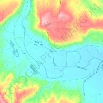
Name: Ceres topographic map, elevation, terrain.

Location: Ceres, Lewis County, Washington, United States (46.58788 -123.17347 46.62788 -123.13347)

Average elevation: 404 ft

Minimum elevation: 194 ft

Maximum elevation: 810 ft

Other topographic maps

Click on a map to view its topography, its elevation and its terrain.

Winlock

United States > Washington > Lewis County

The eastern edge of the Willapa Hills lie to the west. To the east are relatively flat prairies. A notable landmark about four miles west of town is Sam Henry Mountain, elevation 1,492 feet (455 m), named for an early section superintendent of the Northern Pacific Railroad. Mt. St. Helens, about forty miles…

Average elevation: 407 ft

Centralia

United States > Washington > Lewis County

Average elevation: 243 ft

Toledo

United States > Washington > Lewis County

Average elevation: 161 ft

Mineral

United States > Washington > Lewis County > Mineral

Average elevation: 1,572 ft

Mineral Lake

United States > Washington > Lewis County > Mineral

Average elevation: 1,588 ft

Onalaska

United States > Washington > Lewis County

Average elevation: 568 ft

Morton

United States > Washington > Lewis County

Average elevation: 1,076 ft

Chehalis

United States > Washington > Lewis County

Average elevation: 266 ft

Packwood

United States > Washington > Lewis County > Packwood

Average elevation: 1,148 ft

Vader

United States > Washington > Lewis County

Average elevation: 246 ft

Centralia

United States > Washington > Lewis County

Average elevation: 243 ft

Winlock

United States > Washington > Lewis County

The eastern edge of the Willapa Hills lie to the west. To the east are relatively flat prairies. A notable landmark about four miles west of town is Sam Henry Mountain, elevation 1,492 feet (455 m), named for an early section superintendent of the Northern Pacific Railroad. Mt. St. Helens, about forty miles…

Average elevation: 407 ft

Riffe Lake

United States > Washington > Lewis County

Average elevation: 1,650 ft

Centralia

United States > Washington > Lewis County

Average elevation: 243 ft

Toledo

United States > Washington > Lewis County

Average elevation: 161 ft

Vader

United States > Washington > Lewis County

Average elevation: 246 ft

Vader

United States > Washington > Lewis County

Average elevation: 246 ft

Packwood

United States > Washington > Lewis County > Packwood

Average elevation: 1,148 ft

Onalaska

United States > Washington > Lewis County

Average elevation: 568 ft

Chehalis

United States > Washington > Lewis County

Average elevation: 266 ft

Mossyrock

United States > Washington > Lewis County

Average elevation: 699 ft

Gear up for your next adventure:

📶Satellite Messenger - Communication device off‑grid
🔥Fast-Boil Camping Stoves - Efficient cooking systems for quick trail meals
Backpacking Tents - Weight-optimized shelters for multi-day topographic surveys
🎒Trail Energy Bars - High‑calorie bars for hiking energy
🌡️Portable Weather Meter - Track weather conditions on the trail

As an Amazon Associate, this site earns from qualifying purchases at no extra cost to you.