Geolocate

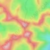
Santa Cruz topographic map

Click on the map to display elevation.

About this map

Name: Santa Cruz topographic map, elevation, terrain.

Location: Santa Cruz, Turrialba, Cartago Province, 30504, Costa Rica (9.94296 -83.81933 10.08383 -83.68256)

Average elevation: 5,919 ft

Minimum elevation: 2,326 ft

Maximum elevation: 10,830 ft

Other topographic maps

Click on a map to view its topography, its elevation and its terrain.
Cerro Chirripó

Costa Rica > Turrialba > Chirripó

Average elevation: 11,808 ft

Gear up for your next adventure:

📖Nature Tracking Books - Learn to track wildlife and terrain
⛺Backpacking Tent - Lightweight and durable tent for multi‑day hikes
🕶️Glacier Sunglasses - Side shields to protect eyes from high-altitude snow glare
🌄Hiking Binoculars - Compact binoculars for scenic views and trail spotting
🔭Stargazing Telescopes - Perfect for camping in low-light pollution areas shown on maps

As an Amazon Associate, this site earns from qualifying purchases at no extra cost to you.