Geolocate

Cenlle topographic map

Click on the map to display elevation.

About this map
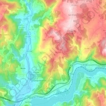
Name: Cenlle topographic map, elevation, terrain.

Location: Cenlle, O Ribeiro, Ourense, Galicia, Spain (42.30236 -8.12435 42.38114 -8.00574)

Average elevation: 810 ft

Minimum elevation: 233 ft

Maximum elevation: 1,660 ft

Other topographic maps

Click on a map to view its topography, its elevation and its terrain.
Berán

Spain > Galicia > O Ribeiro > Leiro

Average elevation: 797 ft

Gear up for your next adventure:

⌚Solar GPS Watches - Advanced multisport watches with built-in topographic maps
🕶️Glacier Sunglasses - Side shields to protect eyes from high-altitude snow glare
🧢Outdoor Hiking Hat - Sun protection hat for outdoor explorers
🕶️GPS Smartphone Mount - Secure mount for phone navigation
🔊Portable Camp Speaker - Music and alerts at camp

As an Amazon Associate, this site earns from qualifying purchases at no extra cost to you.