
Brightwalton topographic map
Click on the map to display elevation.
About this map
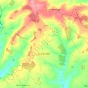
Name: Brightwalton topographic map, elevation, terrain.
Location: Brightwalton, West Berkshire, England, United Kingdom (51.49195 -1.42278 51.54212 -1.36271)
Average elevation: 584 ft
Minimum elevation: 407 ft
Maximum elevation: 758 ft
Other topographic maps
Click on a map to view its topography, its elevation and its terrain.
Walbury Hill
United Kingdom > England > West Berkshire > Combe
Walbury Hill is a summit of the North Wessex Downs in Berkshire, England. With an elevation of 297 metres (974 ft), it is the highest natural point in South East England. On the hill's summit is the Iron Age hill fort of Walbury Camp, whilst the flanks of the hill lie within the Inkpen and Walbury Hills SSSI.…
Average elevation: 728 ft
Aldermaston Wharf
United Kingdom > England > West Berkshire > Aldermaston Wharf
Average elevation: 226 ft
Leckhampstead Thicket
United Kingdom > England > West Berkshire > Leckhampstead
Average elevation: 512 ft
Shefford Woodlands
United Kingdom > England > West Berkshire > Great Shefford
Average elevation: 505 ft