Geolocate

Nijmegen topographic map

Click on the map to display elevation.

About this map
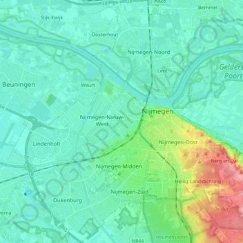
Name: Nijmegen topographic map, elevation, terrain.

Location: Nijmegen, Gelderland, Netherlands (51.79059 5.75762 51.89462 5.90835)

Average elevation: 62 ft

Minimum elevation: 10 ft

Maximum elevation: 312 ft

Other topographic maps

Click on a map to view its topography, its elevation and its terrain.
Nijmegen

Netherlands > Gelderland > Nijmegen

Average elevation: 52 ft

Kops Plateau

Netherlands > Gelderland > Nijmegen

Average elevation: 118 ft

Gear up for your next adventure:

🎒Hydration Pack - Hands‑free water reservoir for long hikes
🌄Hiking Binoculars - Compact binoculars for scenic views and trail spotting
🧯Emergency Survival Kit - All‑in‑one survival essentials for the backcountry
📶Vehicle Signal Boosters - Improve reception in rural areas while driving to trailheads
🌡️Portable Weather Meter - Track weather conditions on the trail

As an Amazon Associate, this site earns from qualifying purchases at no extra cost to you.