Geolocate

Utelle topographic map

Click on the map to display elevation.

About this map

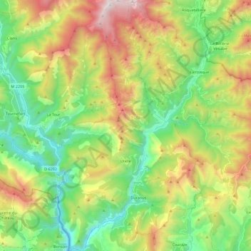
Name: Utelle topographic map, elevation, terrain.

Location: Utelle, Nice, Maritime Alps, Provence-Alpes-Côte d'Azur, Metropolitan France, 06450, France (43.85986 7.18503 44.01883 7.30696)

Average elevation: 2,769 ft

Minimum elevation: 436 ft

Maximum elevation: 6,739 ft

Other topographic maps

Click on a map to view its topography, its elevation and its terrain.

Grasse

France > Provence-Alpes-Côte d'Azur > Maritime Alps > Grasse > Grasse

Average elevation: 1,388 ft

Gear up for your next adventure:

🧭Map Reading Tools - Tools and kits for map navigation
⛑️Personal Locator Beacon - Safety beacon for emergencies
🛡️Insect Repellent - Protection against bugs during outdoor activities
❄️Traction Cleats - Prevent slips on icy trails during winter hikes
🌧️Backpack Rain Cover - Keep gear dry in wet weather

As an Amazon Associate, this site earns from qualifying purchases at no extra cost to you.