
Thank you for supporting this site ❤️
Make a donation
Make a donation
Gear up for your next adventure:
As an Amazon Associate, this site earns from qualifying purchases at no extra cost to you.
Resapombo topographic map
Click on the map to display elevation.
Thank you for supporting this site ❤️
Make a donation
Make a donation
Gear up for your next adventure:
As an Amazon Associate, this site earns from qualifying purchases at no extra cost to you.
About this map
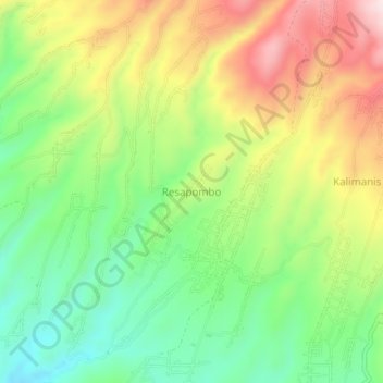
Name: Resapombo topographic map, elevation, terrain.
Location: Resapombo, Blitar, East Java, Indonesia (-8.05914 112.39541 -8.01914 112.43541)
Average elevation: 1,962 ft
Minimum elevation: 1,404 ft
Maximum elevation: 2,710 ft
Thank you for supporting this site ❤️
Make a donation
Make a donation
Gear up for your next adventure:
As an Amazon Associate, this site earns from qualifying purchases at no extra cost to you.