Geolocate

Rangat topographic map

Click on the map to display elevation.

About this map

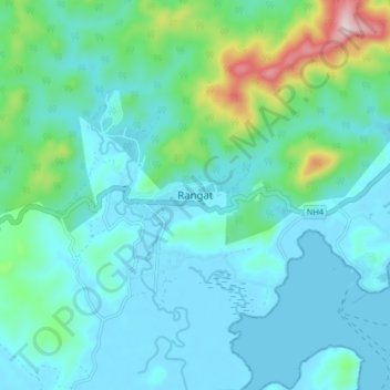
Name: Rangat topographic map, elevation, terrain.

Location: Rangat, North and Middle Andaman District, Andaman and Nicobar Islands, India (12.46701 92.88292 12.54701 92.96292)

Average elevation: 236 ft

Minimum elevation: -7 ft

Maximum elevation: 1,371 ft

Other topographic maps

Click on a map to view its topography, its elevation and its terrain.

Long Island

India > Andaman and Nicobar Islands > Rangat

Average elevation: 36 ft

Gear up for your next adventure:

🛡️Bear Spray Outdoor - Protection in bear country hikes
🔦Compact Flashlight - Reliable flashlight for emergencies
🧢Outdoor Hiking Hat - Sun protection hat for outdoor explorers
📌Outdoor GPS Map App - Apps and devices for digital topographic navigation
🌡️Portable Weather Meter - Track weather conditions on the trail

As an Amazon Associate, this site earns from qualifying purchases at no extra cost to you.