Geolocate

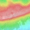
Stadthagen topographic map

Click on the map to display elevation.

About this map

Name: Stadthagen topographic map, elevation, terrain.

Location: Stadthagen, Landkreis Schaumburg, Lower Saxony, 31655, Germany (52.25898 9.12809 52.35204 9.28792)

Average elevation: 449 ft

Minimum elevation: 161 ft

Maximum elevation: 1,220 ft

Other topographic maps

Click on a map to view its topography, its elevation and its terrain.
Gear up for your next adventure:

🛠️Outdoor Gear Repair Kit - Essential tools to fix gear on the trail
🛶Inflatable Kayak - Portable kayak for rivers, lakes, and expeditions
🛡️Bear Spray Outdoor - Protection in bear country hikes
⛑️Personal Locator Beacon - Safety beacon for emergencies
🧼Biodegradable Camping Soap - Eco‑friendly soap for outdoor hygiene

As an Amazon Associate, this site earns from qualifying purchases at no extra cost to you.