
Caraz topographic map
Interactive map
Click on the map to display elevation.
About this map
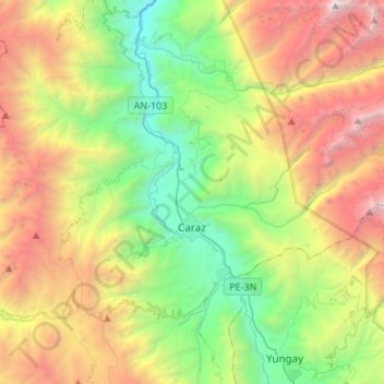
Name: Caraz topographic map, elevation, terrain.
Location: Caraz, Huaylas, Áncash, 02165, Perú (-9.09696 -77.88310 -8.95140 -77.61300)
Average elevation: 11,604 ft
Minimum elevation: 6,250 ft
Maximum elevation: 20,246 ft
Other topographic maps
Click on a map to view its topography, its elevation and its terrain.
Picup
Perú > Áncash > Independencia > Pongor
Picup, Pongor, Independencia, Huaraz, Áncash, 02690, Perú
Average elevation: 10,328 ft
Nuevo Chimbote
Perú > Áncash > Nuevo Chimbote
Nuevo Chimbote, Santa, Áncash, Perú
Average elevation: 318 ft
Garachapampa
Perú > Áncash > San Juan > Andaymayo
Garachapampa, Andaymayo, San Juan, Sihuas, Áncash, Perú
Average elevation: 11,060 ft
Provincia de Huari
Provincia de Huari, Huachis, Huari, Áncash, Perú
Average elevation: 10,443 ft
Provincia de Huaylas
Perú > Áncash > Santa Cruz
Provincia de Huaylas, Santa Cruz, Huaylas, Áncash, Perú
Average elevation: 7,720 ft