
Make a donation
Gear up for your next adventure:
As an Amazon Associate, this site earns from qualifying purchases at no extra cost to you.
Doylestown topographic map
Click on the map to display elevation.
Make a donation
Gear up for your next adventure:
As an Amazon Associate, this site earns from qualifying purchases at no extra cost to you.
Doylestown
An electric telegraph station was built in 1846, and the North Pennsylvania Railroad completed a branch to Doylestown in 1856. The first gas lights were introduced in 1854. Because of the town's relatively high elevation and a lack of strong water power, substantial industrial development never occurred and Doylestown evolved to have a professional and residential character.
Make a donation
Gear up for your next adventure:
As an Amazon Associate, this site earns from qualifying purchases at no extra cost to you.
About this map
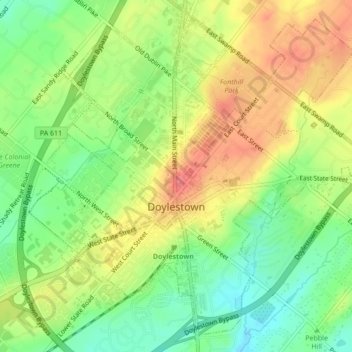
Name: Doylestown topographic map, elevation, terrain.
Location: Doylestown, Bucks County, Pennsylvania, 18901, United States (40.29804 -75.14846 40.32777 -75.10553)
Average elevation: 354 ft
Minimum elevation: 243 ft
Maximum elevation: 469 ft
Bucks County trails, hiking, mountain biking, running and outdoor activities
Make a donation
Gear up for your next adventure:
As an Amazon Associate, this site earns from qualifying purchases at no extra cost to you.
Other topographic maps
Click on a map to view its topography, its elevation and its terrain.
Pipersville
United States > Pennsylvania > Bucks County > Bedminster Township
Average elevation: 410 ft
Langhorne Gardens
United States > Pennsylvania > Bucks County > Middletown Township
Average elevation: 148 ft
Croydon Heights
United States > Pennsylvania > Bucks County > Bristol Township > Croydon
Average elevation: 33 ft
Make a donation
Gear up for your next adventure:
As an Amazon Associate, this site earns from qualifying purchases at no extra cost to you.
Make a donation
Gear up for your next adventure:
As an Amazon Associate, this site earns from qualifying purchases at no extra cost to you.
Kintnersville
United States > Pennsylvania > Bucks County > Nockamixon Township
Average elevation: 371 ft
Tyler State Park
United States > Pennsylvania > Bucks County > Northampton Township
Average elevation: 220 ft
Make a donation
Gear up for your next adventure:
As an Amazon Associate, this site earns from qualifying purchases at no extra cost to you.
Newtown Athletic Club
United States > Pennsylvania > Bucks County > Newtown Township
Average elevation: 161 ft
Blue Ridge
United States > Pennsylvania > Bucks County > Bristol Township > Levittown
Average elevation: 52 ft
Falls Township Community Park
United States > Pennsylvania > Bucks County > Falls Township > Wheat Sheaf
Average elevation: 30 ft
Plumsteadville
United States > Pennsylvania > Bucks County > Plumstead Township
Average elevation: 525 ft
Make a donation
Gear up for your next adventure:
As an Amazon Associate, this site earns from qualifying purchases at no extra cost to you.
Taylorsville
United States > Pennsylvania > Bucks County > Upper Makefield Township > Washington Crossing
Average elevation: 121 ft
Springtown
United States > Pennsylvania > Bucks County > Springfield Township
Average elevation: 535 ft
Make a donation
Gear up for your next adventure:
As an Amazon Associate, this site earns from qualifying purchases at no extra cost to you.
Blue Ridge
United States > Pennsylvania > Bucks County > Bristol Township > Levittown
Average elevation: 52 ft
Wrightstown
United States > Pennsylvania > Bucks County > Wrightstown Township
Average elevation: 279 ft
Mechanicsville
United States > Pennsylvania > Bucks County > Buckingham Township
Average elevation: 384 ft
Make a donation
Gear up for your next adventure:
As an Amazon Associate, this site earns from qualifying purchases at no extra cost to you.
Southampton
United States > Pennsylvania > Bucks County > Upper Southampton Township
Average elevation: 246 ft
Southampton
United States > Pennsylvania > Bucks County > Upper Southampton Township
Average elevation: 246 ft
Make a donation
Gear up for your next adventure:
As an Amazon Associate, this site earns from qualifying purchases at no extra cost to you.
Landisville
United States > Pennsylvania > Bucks County > Buckingham Township
Average elevation: 397 ft
Make a donation
Gear up for your next adventure:
As an Amazon Associate, this site earns from qualifying purchases at no extra cost to you.
Woodbourne
United States > Pennsylvania > Bucks County > Middletown Township
Average elevation: 157 ft
Blooming Glen
United States > Pennsylvania > Bucks County > Hilltown Township
Average elevation: 430 ft
Make a donation
Gear up for your next adventure:
As an Amazon Associate, this site earns from qualifying purchases at no extra cost to you.
Eddington Gardens
United States > Pennsylvania > Bucks County > Bensalem Township > Eddington Gardens
Average elevation: 95 ft
Croydon
United States > Pennsylvania > Bucks County > Bristol Township > Croydon
Average elevation: 26 ft
Red Cedar Hill
United States > Pennsylvania > Bucks County > Bristol Township > Levittown > Red Cedar Hill
Average elevation: 69 ft
Make a donation
Gear up for your next adventure:
As an Amazon Associate, this site earns from qualifying purchases at no extra cost to you.
Kintnersville
United States > Pennsylvania > Bucks County > Nockamixon Township
Average elevation: 371 ft
Bridge Point
United States > Pennsylvania > Bucks County > Doylestown Township
Average elevation: 269 ft
Make a donation
Gear up for your next adventure:
As an Amazon Associate, this site earns from qualifying purchases at no extra cost to you.