
Make a donation
Gear up for your next adventure:
As an Amazon Associate, this site earns from qualifying purchases at no extra cost to you.
Castiñeira topographic map
Click on the map to display elevation.
Make a donation
Gear up for your next adventure:
As an Amazon Associate, this site earns from qualifying purchases at no extra cost to you.
About this map
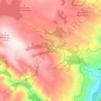
Name: Castiñeira topographic map, elevation, terrain.
Location: Castiñeira, Vilariño de Conso, Viana, Orense, Galicia, España (42.16211 -7.26450 42.19337 -7.18706)
Average elevation: 4,026 ft
Minimum elevation: 2,198 ft
Maximum elevation: 5,030 ft
Make a donation
Gear up for your next adventure:
As an Amazon Associate, this site earns from qualifying purchases at no extra cost to you.
Other topographic maps
Click on a map to view its topography, its elevation and its terrain.
Parque Natural O Invernadeiro
España > Galicia > Viana > Vilariño de Conso
Es un paisaje de carácter montañoso situado al sur del macizo Central, en la provincia de Orense, entre los ríos Ribeira Grande y Ribeira Pequeña, y formado por la sierra de San Mamede, Queixa, Manzaneda y el Fial das Corzas, que constituyen el macizo Central orensano, con altitudes de alrededor de…
Average elevation: 4,091 ft