Geolocate

Bad Schwalbach topographic map

Click on the map to display elevation.

About this map

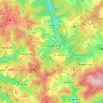
Name: Bad Schwalbach topographic map, elevation, terrain.

Location: Bad Schwalbach, Rheingau-Taunus-Kreis, Hesse, 65307, Germany (50.09520 7.95634 50.17806 8.10269)

Average elevation: 1,385 ft

Minimum elevation: 830 ft

Maximum elevation: 2,037 ft

Other topographic maps

Click on a map to view its topography, its elevation and its terrain.

Dickschied

Germany > Hesse > Rheingau-Taunus-Kreis

Average elevation: 1,175 ft

Kalte Herberge

Germany > Hesse > Rheingau-Taunus-Kreis > Hallgarten

Average elevation: 1,699 ft

Hohe Wurzel

Germany > Hesse > Rheingau-Taunus-Kreis > Taunusstein

Average elevation: 1,670 ft

Gear up for your next adventure:

🎒Trail Energy Bars - High‑calorie bars for hiking energy
🦶Hiking Gaiters - Keep debris and water out of your boots
🪶Fire Starter Kit - Reliable fire starter for survival and camping
Camping Coffee Makers - Enjoy premium coffee at the summit or campsite
🎒Outdoor Daypacks - Lightweight backpacks designed for carrying maps and essential gear

As an Amazon Associate, this site earns from qualifying purchases at no extra cost to you.