
Thank you for supporting this site ❤️
Make a donation
Make a donation
Gear up for your next adventure:
As an Amazon Associate, this site earns from qualifying purchases at no extra cost to you.
Challancin topographic map
Click on the map to display elevation.
Thank you for supporting this site ❤️
Make a donation
Make a donation
Gear up for your next adventure:
As an Amazon Associate, this site earns from qualifying purchases at no extra cost to you.
About this map
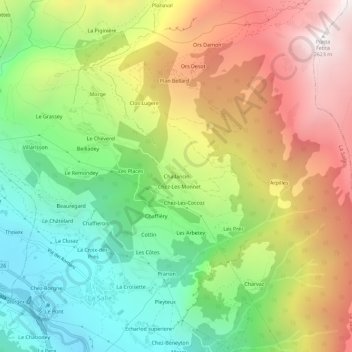
Name: Challancin topographic map, elevation, terrain.
Location: Challancin, La Salle, Valle d'Aosta, 11015, Italia (45.73923 7.06308 45.77923 7.10308)
Average elevation: 5,335 ft
Minimum elevation: 2,825 ft
Maximum elevation: 8,560 ft
Thank you for supporting this site ❤️
Make a donation
Make a donation
Gear up for your next adventure:
As an Amazon Associate, this site earns from qualifying purchases at no extra cost to you.