Geolocate

Ravenswood topographic map

Click on the map to display elevation.

About this map

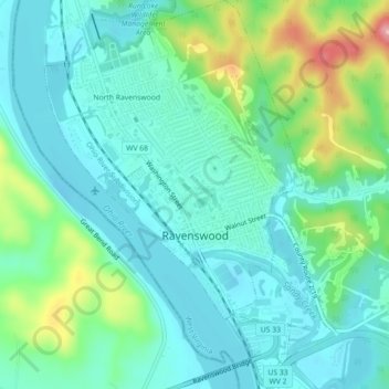
Name: Ravenswood topographic map, elevation, terrain.

Location: Ravenswood, Jackson County, West Virginia, United States (38.93457 -81.77832 38.96934 -81.74472)

Average elevation: 659 ft

Minimum elevation: 554 ft

Maximum elevation: 978 ft

Jackson County trails, hiking, mountain biking, running and outdoor activities

Other topographic maps

Click on a map to view its topography, its elevation and its terrain.

Kenna

United States > West Virginia > Jackson County

Average elevation: 906 ft

New Era

United States > West Virginia > Jackson County

Average elevation: 715 ft

Gear up for your next adventure:

🧷Carabiner Set - Durable clips for gear attachment
🪓Survival Multi‑Tool - Versatile tool for camp and trail tasks
📡Handheld GPS Device - Reliable handheld GPS for outdoor navigation
🧭Map Reading Tools - Tools and kits for map navigation
🧤Hiking Gloves - Protective gloves for rugged trails

As an Amazon Associate, this site earns from qualifying purchases at no extra cost to you.