
Harrisburg topographic map
Click on the map to display elevation.
Harrisburg
Harrisburg is located at 37°44′2″N 88°32′45″W / 37.73389°N 88.54583°W / 37.73389; -88.54583 (37.733765, −88.545873). According to the 2010 census, Harrisburg has a total area of 6.759 square miles (17.51 km2), of which 6.55 square miles (16.96 km2) (or 96.91%) is land and 0.209 square miles (0.54 km2) (or 3.09%) is water. The square in the center of town, as well as Dorrisville and Gaskins City, stand on top of a series of sandstone bluffs that were once islands rising above natural lowlands, 338 feet (103 m) above sea level, dredged by the middle fork of the Saline River. The Saline River was a navigable river used by early settlers for transportation to and from Salt Works just east of Harrisburg. The Saline flowed towards the Ohio and flooded every spring in events called Freshets. The locals called the island "Crusoe's Island". When the area was drained, homes and businesses were built in the floodplain, and it became prone to serious flooding for years to come. The town square in the center of town is a sandstone bluff 410 feet (125 m) above sea level, one of the first that start the Shawnee Hills to the south. Topographic maps show the bluffs that rise from the Saline River that wraps the northeast part of the city. Harrisburg is located at the ending point of the Laurentide Ice Sheet, which covered about 85 percent of Illinois. The edge of Illinoian ice sheet(s) lay further south than the southernmost extent, i.e. Douglas County, Kansas, of any of the Pre-Illinoian ice sheets.
About this map
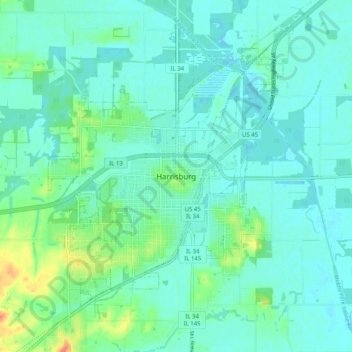
Name: Harrisburg topographic map, elevation, terrain.
Average elevation: 377 ft
Minimum elevation: 348 ft
Maximum elevation: 489 ft
Saline County trails, hiking, mountain biking, running and outdoor activities