
Bakersfield topographic map
Click on the map to display elevation.
Bakersfield
Most of Bakersfield’s major streets are six-lane divided roads with bike lanes, with almost every street in the city having proper lane signage for bicycle traffic. Bikes are a popular method of transportation in Bakersfield, due to the city’s relatively flat topography and grid-like street system. Newer neighborhoods on the outskirts of the city, previously surrounded by two-lane farm roads, are prompting more large, divided roads to be built to help ease the increase in traffic that has resulted from an explosion in population. Many developers choose to widen the roads that connect these neighborhoods at their own discretion, which can cause a major road to widen and narrow repeatedly over a short distance (Allen Road and Panama Lane are prime examples of this). Since the Bakersfield city limit boundaries are not uniform and leap over different neighborhoods, this can cause Kern County “islands” to exist within Bakersfield. The county of Kern may choose not to upgrade a road while the city of Bakersfield does improve a road, which can cause traffic congestion to increase (Calloway Drive from the Westside Parkway north to Rosedale Highway best exemplifies this disparity).
About this map
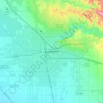
Name: Bakersfield topographic map, elevation, terrain.
Location: Bakersfield, Kern County, California, 93301, United States (35.21387 -119.17946 35.53387 -118.85946)
Average elevation: 528 ft
Minimum elevation: 292 ft
Maximum elevation: 2,028 ft
Kern County trails, hiking, mountain biking, running and outdoor activities